 63. Nautical map by G. Petrucci
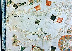
A list dated 10 March 1744 describing some "Furniture taken from the Museo Cospiano and placed in the Geographic and Nautical Room in the Institute of Science" shows how this map and another by Banet Panadès [file 64] come from the collection of the marquis Ferdinando Cospi, donated to the Bolognese Senate in 1660 and transferred around 1740 to the Institute of Science on the orders of Benedict XIV (Prospero Lambertini). Restored in 1969, it charts the whole Mediterranean basin. It stretches from the Black Sea, with the Crimea peninsula, in the east to the part of the Atlantic Ocean facing Europe and Africa in the west. In the north the coasts map out Denmark and a piece of Scandinavia, as far as the Orkney Islands. To the south the map ends in Africa with the Rio de S. Giouanni and the Atlas mountain chain.
The languages used are Italian and Latin and the different colorings represent different geographical features: rivers in green; mountains in brown, red, green and violet; lakes in blue; towns in black or red, depending on their importance. In the Red Sea (Mare Rubrum) the parting of the waters can be seen marking the passage of the Hebrews. Many cities are indicated by castles and flags with coat-of-arms. The perspective maps of Genoa, Venice and Jerusalem are rich in detail. The kingdoms are represented by the sovereigns sitting on their thrones or the sultans sat on sumptuous cushions.
The inscription reads:
Hoc Opus Fecit Julius Cesaris Petrucij Civis Senar
In Civitate Pisar~. Anno Dni M.D.LXXI.
P. Frabetti (1959).
P. Frabetti (1978), p. 81.